Environmental Plantings (ACCU) Assessment
Understand whether tree planting for carbon is likely to be commercially viable on your property — before committing to planting, project development, or long-term obligations. This desktop feasibility assessment uses spatial analysis and government-approved carbon modelling to identify areas of your land that may support an Environmental Plantings project under the ACCU scheme.
Enquire About This Assessment
Is this service right for me?
This assessment is designed for landholders considering establishing native trees or shrubs for carbon, biodiversity, shelter, or landscape resilience, and who want clarity before investing time or capital.
Typically a good fit if...
- Have cleared or historically grazed land with low existing tree cover
- Are considering block-style environmental plantings
- Want to understand carbon income potential before planting
- Are in moderate to higher rainfall zones
- Prefer independent advice before engaging developers or contractors
May not be right for you if...
- Already have established tree cover across the area of interest
- Are primarily interested in soil carbon or regeneration-based methods
- Need a whole-of-farm comparison across multiple natural capital options
The natural capital journey
We believe in taking small, safe steps before big leaps. Our role is to help you decide whether to proceed — before costs, commitments, or long-term obligations begin.
We focus on clarity
Too many feasibility studies deliver pages of charts but no clear answer. We frame our assessment around the practical questions that determine if a project makes financial and operational sense for you and your land.
How is planting viability assessed?
We identify areas estimated to generate at least 10 tCO₂-e per hectare per year, averaged over a 25-year crediting period, using the Australian Government’s FullCAM model.
What planting configuration is assumed?
Modelling assumes a block planting configuration, consistent with Environmental Plantings ACCU method requirements.
What do the maps show?
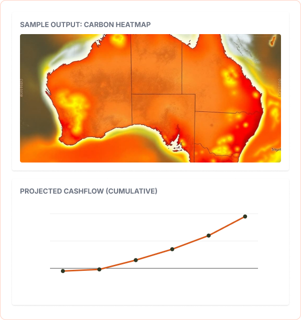
Indicative spatial heat maps highlight areas that may be commercially viable, supporting early-stage decision-making before any on-ground works.
WHAT’S INCLUDED IN YOUR EP ASSESSMENT
We provide tangible, data-backed outputs designed to support practical planning and informed decision-making for your farm’s future.
- GIS mapping and spatial analysis
Detailed mapping of your property's topography and vegetation.
- Regulatory eligibility screening
Checks against current legislation and methodology requirements.
- Carbon yield modelling (FullCAM)
to identify areas estimated to generate ≥10 tCO₂-e/ha/year over 25 years.
- Spatial heat maps showing planting suitability
Visual guides identifying the best and worst areas to plant.
- Written feasibility and recommendations report
High-resolution maps identifying exclusion zones, eligible planting areas, and soil carbon stratification zones based on satellite data.
- Online results workshop
A guided session to walk you through the data and answer questions.
Frequently Asked Questions
Typically: property location and boundaries (or lot/plan details), current land use and management context, any known constraints, and your goals. If you don’t have digital boundary files, you can still start with basic property details.
Renovo Ag can help you understand what formal project development involves and can scope support for later stages, but a services-page engagement often focuses on feasibility, planning, and decision-making. Registration and delivery are typically separate, later-stage scopes.
Renovo Ag is an advisory business. On-ground works (planting, fencing, weed control, management changes, etc.) are usually carried out by landholders and/or specialist contractors. We can help clarify what’s required and how it fits into an overall plan.
Yes—where helpful, Renovo Ag can suggest the types of specialists you may need (e.g., ecologists, agronomists, contractors) and help you assemble a delivery team appropriate to the pathway and location.
Timeframes depend on the service type, property complexity, and data availability. You’ll be given an expected timeline at the start of the engagement, and the work is typically structured around an onboarding step, analysis, and a results discussion.
explore our other assessments
Not sure if this service is the right fit? Check out our other options.
NSW Biodiversity Credits Assessment
Desktop biodiversity assessment including project area mapping, credit yield estimates, demand assessment, historical trades/pricing, and a feasibility report.
Property Sourcing Services
Spatially explicit investment modeling to identify properties with high-value natural capital potential. Includes feasibility assessments and technical due diligence support.
Biodiversity Credit Brokerage
Expert brokerage services for biodiversity credits, helping landholders find buyers and manage transactions efficiently. Includes access to our market data insights.
Natural Capital Property Planning Workshop
A standard three-day natural capital farm planning program: method fundamentals and property-specific feasibility reports; a project site visit; and a practical farm planning workshop with mapped scenarios and financial returns.
Soil Carbon (ACCU) Assessment
Soil carbon advisory within whole-farm natural capital planning. Renovo Ag does not develop or register soil carbon projects.

Environmental Plantings (ACCU) Assessment
Understand whether tree planting for carbon is likely to be commercially viable on your property — before committing to planting, project development, or long-term obligations. This desktop feasibility assessment uses spatial analysis and government-approved carbon modelling to identify areas of your land that may support an Environmental Plantings project under the ACCU scheme.
